A Native Hawaiian Place of
Learning for Voyagers of the World
Menu
MENU
Menu
The traditional hālau wa’a was a longhouse, a covered structure near the shoreline dedicated to all matters related to canoes, and whose linear measure could provide ample shelter for vessels of sizeable length.
Modern Methods and Techniques of Non-Instrument Navigation, Based on Pacific Traditions
Before the invention of the compass, sextant and clocks, or more recently, the satellite-dependent Global Positioning System (GPS), Pacific Islanders navigated open-ocean voyages without instruments, using instead their observations of the stars, the sun, the ocean swells, and other signs of nature for clues to direction and location of a vessel at sea.
In the 20th century, this method was still practiced in some areas of Micronesia, although the traditional knowledge and techniques are in danger of being lost because of modernization and Westernization of the island cultures.
To learn more, check out www.hokulea.com
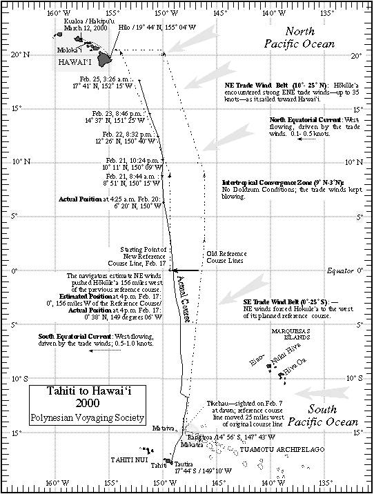
Designing a Course Strategy
Before you set sail, a wayfinder must design a course strategy. This is a plan that will help you arrive at your destination quickly and safely. But be aware! A wayfinder’s course strategy will change along the way! You’ll need to determine your position (where you are) and chart your strategy as you sail!
To learn more, check out http://archive.hokulea.com/ike/hookele/course_strategy.html
Click to Enlarge Image
Building A Star Compass
Follow a group of young voyagers as they work with Nainoa Thompson to build their own star compass. Using the sun as their reference point they align 32 equal houses on a cleared area that is 30 feet in diameter.